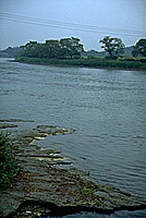
Kitakamigawa River
Roughly speaking, Iwate's topography is formed by the Ou mountain range--the backbone of the Tohoku region, the gentle slopes of the Kitakami mountain area, and the Kitakamigawa river basin.
The Kitakamigawa, the principle river in the Tohoku region, flows vertically through the middle of the prefecture,forms the Sendai basin, and empties into Sendai Bay. Until the Tokhoku train line opened, the river was central to transport and the transmission of culture in the region.
The river basin is more like a wide valley: as Kenji pointed out, it had been an ocean inlet many times in the two million years since the beginning of the interglacial Quaternary period.
Now that dams have been built in most of the upper tributaries, the Kitakamigawa has become a docile river, but in Kenji's day it was rough, and water disasters were not uncommon.
|
During the fifteen days of summer school, there was a place we would often go,every two or three days after we'd finished a certain amount of work.
We nicknamed it the English seashore.
It wasn't really a seashore, just a river bank that closely resembled
the seashore on the west bank of the Kitakamigawa river.
Wide blocks of blue-white tuffaceous mudstone were exposed all along the river there.
Every time the river swelled it would wash this mudstone stratum clean.
It's hard to describe how refreshingly pure blue-white it was.
As a matter of fact, calling that place the English seashore wasn't so unreasonable, because at around the end of the geological age called the Tertiary period, the riverbank here was the shore of the ocean.
The Complete Works of Miyazawa Kenji Vol.6, Chikuma Bunko
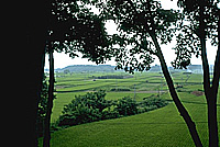 The view from the river terrace where the Rasu Farmers Association was located. |
=> Kenji's diagram of a river terrace
