Nametoko Mountain
Kenji's story, "The Bears of Nametoko," begins like this:
It's interesting, that business of the bears on Mt. Nametoko. Nametoko is a large mountain, and the Fuchizawa River starts somewhere inside it. On most days of the year, the mountain breathes in and breathes out cold mists and clouds. The peaks all around it, too, are like blackish green slugs or bald sea goblins..........
At the entrance to Namari hot spring there is a sign that says "Bear's Liver from Mt. Nametoko." So there are definitely bears on the mountain. I can almost see them, going across the valleys with their pink tongues lolling out, and the bear cubs wrestling with each other till finally they lose their tempers and box each other's ears.
You know, the bears of Nametoko are interesting. Nametoko is a big mountain. Fuchizawagawa river flows from Nametoko Mountain. Most days of the year Nametoko is either breathing in or breathing out the cold mist or clouds. From olden days there's been a sign at the entrance of Namari-no-Yu Hot Spring that says "Nametoko Bear Livers Here." That's why the bears on Nametoko cross over the valley with their red tongues lolling out. The baby bears play at sumo wrestling and end up pounding on each other.Excerpt from Once and FOREVER, the tales of kenji miyazawa,
translated by John Bester, published by Kodansha International
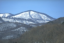 Nametoko Mountain sports a "Mohican cut." (Photo provided by Hiroshi Okuda) |
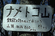 Who put this sign up? (Photo provided by Hiroshi Okuda) |
The Kuzumaru, Dai, and Toyosawa Rivers
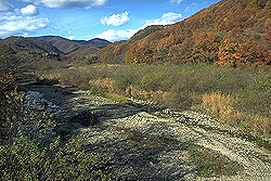 Toyosawagawa River (upper Toyosawa Dam) (Photo provided by Hiroshi Okuda) |
Miyazawa Kenji was a geologist. The Kuzumarugawa, Daigawa, and Toyosawagawa, tributaries of the Kitakamigawa River near Hanamaki were the fields where Kenji searched for rocks and where he often took students from Hanamaki Agricultural School on outdoor field trips.
Kenji graduated from Morioka Upper Agricultural and Forestry School (now the Agricultural Department of Iwate University) and, at the request of his professor, conducted a geological survey of Hienuki-gun in the river basin where these rivers flow and the place where Nametoko Mountain is located. Kenji left a detailed route map titled "Geological Survey Progress Map" and a hand-drawn geologic map.
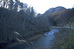 The Kuzumarugawa River (Photo provided by Hiroshi Okuda) |
Kenji wrote a poem about finding liparite in the river and being proud to discover that the volcano there was older than Mt. Iwate.
